Keeldragger Sailing
SoCal

Catalina, the Channel Islands, and the Southern California coast, thought through.

Offline NOAA charts, the forecast as a moving picture, marine weather scored against your own limits, live Coast Guard notices on your route, an anchor alarm on watch with you — and a first-hand anchorage guide written by sailors who anchored there. From your first mooring pickup to the shipping lanes at dawn.

Join the Beta on TestFlight iPhone, iPad & Mac
Coming soon to the App Store
Open the Web App Any browser, no install
Plan the passage from anywhere
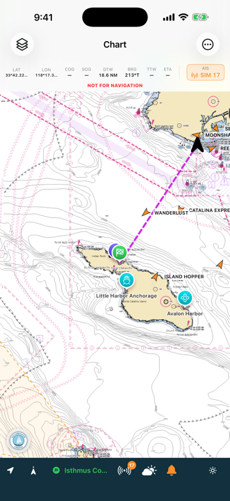
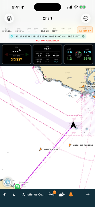
NOAA chart of the crossing from San Pedro to Catalina with a course line to Isthmus Cove

The skipper decides.

SoCal renders no verdicts. There's no green light to sail and no red light to stay — because that call belongs to you, and it always will. What the app does is put the information in front of you: the forecast in the words NWS wrote, the buoys reporting what the water is actually doing, the Coast Guard notices that touch your route, and the shipping lanes you're about to cross.

Pick a destination and the app quietly checks the route. If a gale warning or a rocket-launch safety zone sits across your track — or the straight line runs over an island, or the arrival works out to after dark at your own cruise speed — it stands in front of you before you commit. Once, clearly, and then it hands the decision back.

Every passage card is borrowed experience from boats that made these crossings before you. Read it at the dock, carry it offline, and make the call like the skipper you are.

The web edition: the same chart, from any browser.

Plan the passage from the kitchen table, the office, or a phone with no room for another app. app.socal.keeldragger.com runs the same charts, forecasts, notices and analyzers as the app — nothing to install.

Plan anywhere

Routes, plans, the printed page

Draw a route over the NOAA chart, get every leg's bearing, distance, time and arrival light, the shipping-lane crossings and the depth under your draft, and print the passage plan — the same arithmetic the app does, tested against it.

The picture

Weather, notices, the marine layer

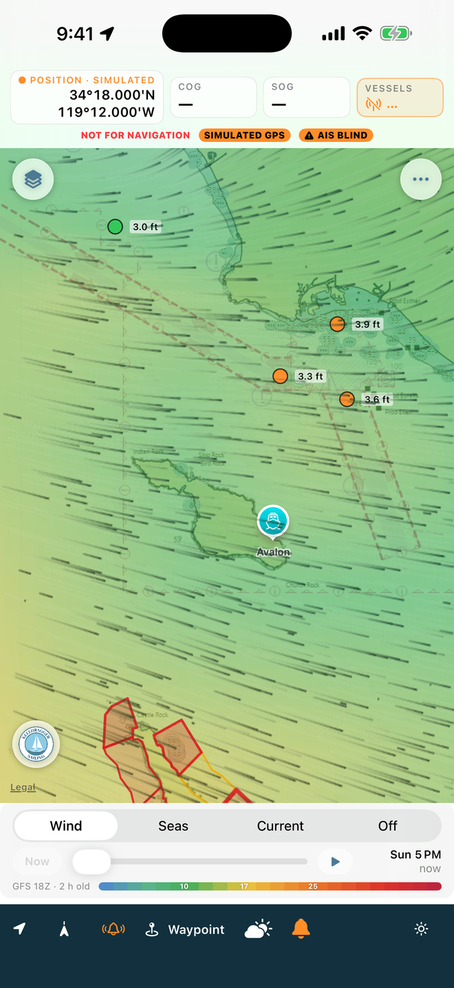
Live NWS advisories shaded on the chart, the wind, seas and current fields as a moving picture three days out, buoys, tides, whales, and the GOES marine layer with three hours of history — refreshed while the tab stays open.

Your boat

Reads the phone, syncs the rest

Signed into iCloud, it reads the waypoints, routes, cards and log your phone keeps. With a free Keeldragger account, routes, waypoints, cards, the log and photos travel both ways between the browser and the apps.

What stays aboard

Where the app is the app

A browser has no GPS worth trusting under way, no AIS, no boat network, no anchor watch — so the web edition plans and reviews; the app at the helm navigates. The two are built from the same source, one ahead of the other by days at most.

Open the Web App app.socal.keeldragger.com
Free, no install, no account needed to start

The reference shelf for these waters.

Built for the Southern California Bight — all eight Channel Islands, Catalina, and the mainland coast from Point Conception to San Diego.

Charts

NOAA charts, fully offline

Real NOAA electronic-chart tiles with soundings deep enough to pick your spot in a crowded cove. Download once at the dock; mid-channel there is no signal, and the chart doesn't care. Satellite imagery one tap away for reading kelp, sand patches, and mooring rows.

Weather

The forecast, against your limits

NWS marine forecasts and live buoy reports for the waters you're actually crossing. Set your own wind and sea limits and the departure matrix highlights every forecast period that exceeds them — in red, in the forecast's own words.

Notices to Mariners

The paperwork, in one place

Weekly Local Notices and live Broadcast Notices from Coast Guard District 11, filtered to what's near your route. Active hazard zones — live fire, rocket launches, safety areas — draw themselves on the chart and expire with the broadcast.

Passage Cards

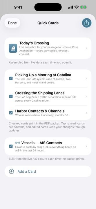
Quick cards for the moments that matter

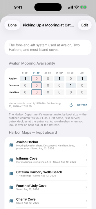
Picking up a fore-and-aft mooring, crossing the LA/Long Beach lanes, and the harbor contacts and VHF channels that matter once you're there — each card carrying your own boat's details. Avalon's live mooring availability with your boat's size column highlighted, and the official harbor maps cached for offline reading.

Today's Crossing

Your passage on one page

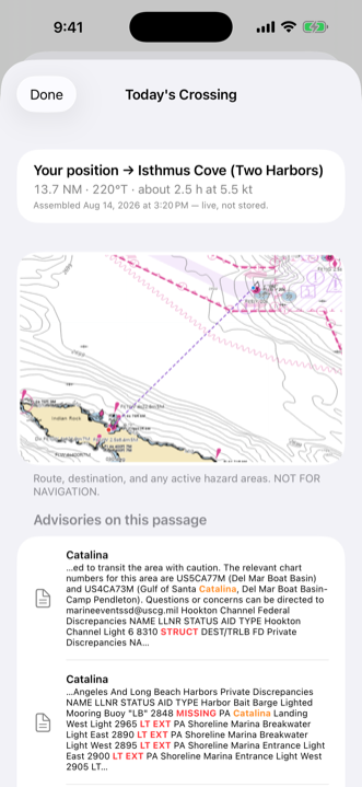
Pick a destination and get a live briefing — chart snapshot with your route, advisories on the track, the forecast, and a shipping-lane warning when your course crosses one. Print it with the cards as one packet for the nav station.

Animated Weather

The forecast as a moving picture

Wind, seas, or surface current as a living field over the chart — colour, particles, and crest lines from NOAA's own GFS, GFS-Wave, and RTOFS models. Scrub three days into the future; the model and its age are named right beside the slider, and a tap reads the number under your finger.

Alarms

An anchor alarm on watch with you

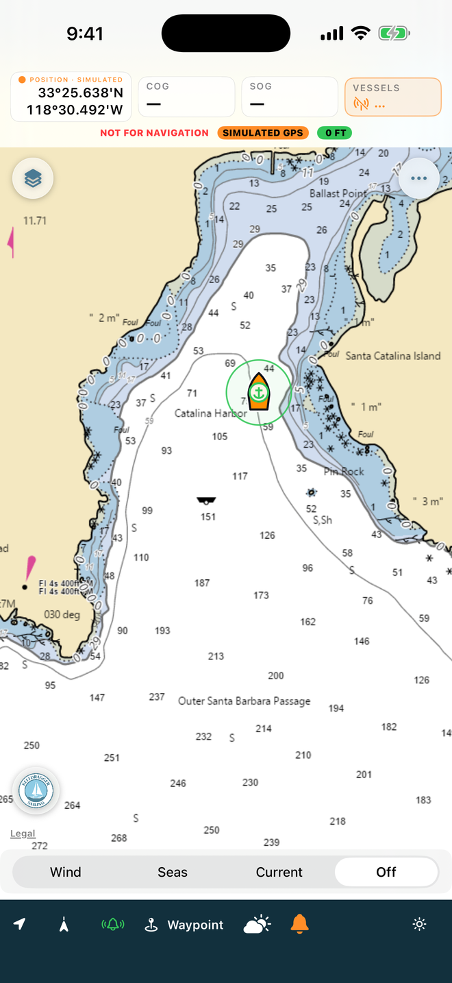
Drop the pin and set the circle — the rode helper suggests a radius from the scope you actually paid out — and the alarm sounds if the boat leaves it. A CPA collision watch solves every AIS target continuously, and wind and depth alarms cover the williwaw night. Armed alarms keep running with the screen locked.

Anchorages

A cruising guide written at anchor

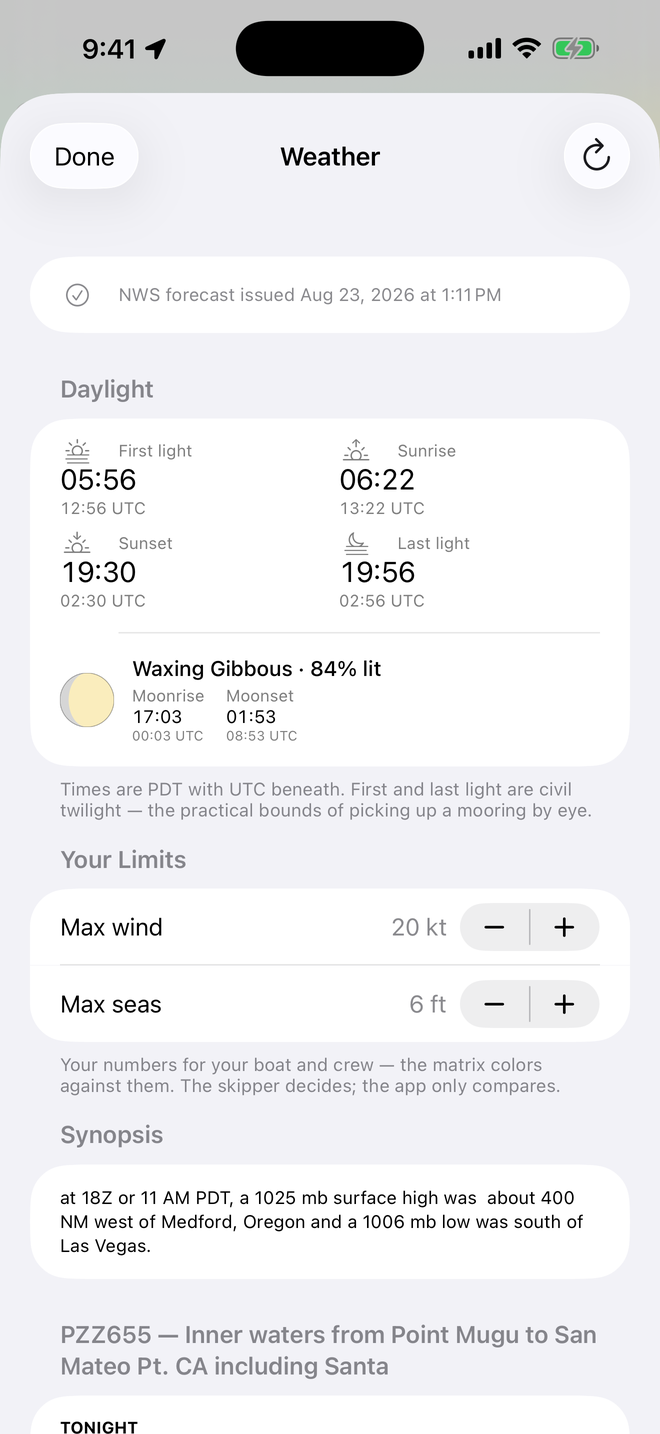
Every published waypoint is first-hand — approach notes, holding, depth, moorings, exposure, photos — written by a sailor who anchored there. Add your own notes, photos, and waypoints on top; the guide updates over the air and never overwrites your margin notes. Sunrise, sunset, and tonight's moon are computed aboard, offline.

AIS & Instruments

Your boat's data, on deck

With an NMEA Wi-Fi router aboard — a PredictWind DataHub, a Yacht Devices YDNR-02, or similar — the chart shows live AIS targets — names, range, CPA — and a proper instrument display puts wind, depth, and speed alongside the chart. GPS position, course, and speed work on every boat, router or not.

On the phone at the helm. On the Mac at the chart table. In the browser from anywhere.

The same cards, notes, and vessel record on every device, kept in step through your own iCloud account — and the web edition reads your boat the same way, so the route you draw on a laptop at home is waiting on the phone at the dock.

NOAA chart of the crossing from San Pedro to Catalina with a course line to Isthmus Cove, AIS targets, and waypoints
Underway to Isthmus Cove — course line, waypoints, live AIS
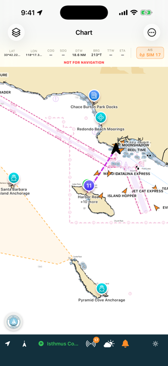
Chart with a live Small Craft Advisory shaded amber over the outer waters
Advisories shaded on the chart — this SCA was live
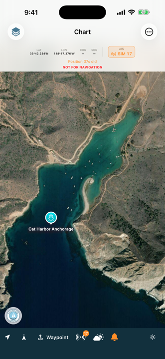
Satellite close-up of Cat Harbor showing the mooring rows and anchorage
Cat Harbor from above — every mooring, before you commit
Chart with live AIS targets and an instrument display fed by the boat's NMEA network
Live AIS and instruments — straight off your boat's network
Animated wind forecast over the chart of the Catalina channel, with the Wind/Seas/Current selector and forecast slider
The wind field, alive — scrub three days ahead
Anchor watch circle drawn around the boat in Catalina Harbor with a live distance readout
The anchor alarm — your swing circle, watched
Daylight panel with sunrise, sunset, first and last light in local and UTC, and tonight's moon phase
Daylight & moon — computed aboard, no signal needed
Mooring card with live Avalon availability table and harbor maps
Avalon availability, live — your size column boxed
Today's Crossing briefing with chart snapshot and advisories
Today's Crossing — the passage on one page
Quick cards list from first crossing to kelp and prop fouling
Passage cards — editable, printable, yours

Built for the whole trip

1 · Planning at home

Even well inland, passages plan from your home port. Study the charts, watch the weather develop against your limits, and print the cards packet before you drive to the boat.

2 · The morning you go

One look at Today's Crossing: advisories on the route, the departure matrix, and whether Avalon actually has a mooring in your size.

3 · Out there, offline

Charts, cards, cached notices and harbor maps — all aboard with no signal. Your position, course, and speed run on the phone's own GPS.

4 · The hook down

The comfort score reads tonight's swell against the cove's real openings, and the anchor alarm keeps an extra eye on your swing — armed alarms keep running with the screen locked.

Your data is your data.

Stored on your devices

Your notes, photos, cards, and vessel record live locally on your iPhone, iPad, and Mac. If you turn on sync, they travel through your own private iCloud account — and nowhere else.

No accounts. No tracking.

No sign-up, no analytics, no third parties. Your position is used only while the app is open, only to show your boat on the chart — and it never leaves the device.

You choose what leaves the boat

Nothing is shared until you export it — cards and crossings as PDF, to exactly the people you choose. Exported photos are scrubbed of location metadata automatically.

How this app was made. This software was developed with AI-assisted coding tools, then tested and corrected by hand. The data is real. Forecasts, buoy readings, notices to mariners, charts, bathymetry, tides and imagery come from NOAA, the National Weather Service, the Coast Guard, USGS and NASA, and where a source is not a government agency, such as Whale Safe sightings, UCLA's kelp survey, the harbors' own mooring tables and maps, or MarineCadastre's traffic counts, it is named on screen. What the app does with that data is what a navigator does with it: selects it, crops and resamples it, draws it, and does arithmetic on it, such as times and distances, the state of the tide between the published highs and lows, a comfort score, the depth under your draft. Every quote is in the source's own words, every computed number is labelled as computed, and nothing is invented, guessed or embellished. And every waypoint is first-hand: written and edited by hand by a sailor with local knowledge who has actually visited that place, anchored there, landed there. None of it is machine-generated or scraped from a gazetteer. First-hand still is not a survey — moorings move and permits change — so read it as a good sailor's notes and confirm what matters with your own eyes.
Not for navigation. Keeldragger Sailing SoCal is reference and planning material. Its charts are NOAA-derived but not certified for navigation, its forecasts are the government's own and can be wrong, and its guidance is a starting point — not local knowledge, not a lookout, and not seamanship. Navigate by official charts and publications, proper instruments, and your own eyes. The captain or master remains solely responsible for the vessel, the crew, and safe passage, and the developer assumes no liability for the app's use or its output.